


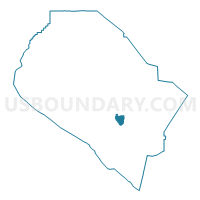
Voting District 50786, Orange County, California
About
Outline

Summary
| Unique Area Identifier | 535986 |
| Name | Voting District 50786 |
| County | Orange County |
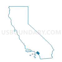
| State | California |
| Area (square miles) | 3.34 |
| Land Area (square miles) | 3.34 |
| Water Area (square miles) | 0.00 |
| % of Land Area | 100.00 |
| % of Water Area | 0.00 |
| Latitude of the Internal Point | 33.57680920 |
| Longtitude of the Internal Point | -117.68976020 |
Maps

Graphs
Select a template below for downloading or customizing gragh for Voting District 50786, Orange County, California


Neighbors
Neighoring Voting District (by Name) Neighboring Voting District on the Map
- Voting District 50486, Orange County, CA
- Voting District 50501, Orange County, CA
- Voting District 50511, Orange County, CA
- Voting District 50776, Orange County, CA
- Voting District 50791, Orange County, CA
- Voting District 50796, Orange County, CA
- Voting District 50886, Orange County, CA
- Voting District 50891, Orange County, CA
- Voting District 50896, Orange County, CA
- Voting District 50901, Orange County, CA
- Voting District 50916, Orange County, CA
- Voting District 50926, Orange County, CA
Top 10 Neighboring County Subdivision (by Population) Neighboring County Subdivision on the Map
Top 10 Neighboring Place (by Population) Neighboring Place on the Map
- Mission Viejo city, CA (93,305)
- Laguna Niguel city, CA (62,979)
- Aliso Viejo city, CA (47,823)
- Laguna Hills city, CA (30,344)
- Laguna Woods city, CA (16,192)
Top 10 Neighboring Unified School District (by Population) Neighboring Unified School District on the Map
- Capistrano Unified School District, CA (343,291)
- Saddleback Valley Unified School District, CA (205,432)
Top 10 Neighboring State Legislative District Lower Chamber (by Population) Neighboring State Legislative District Lower Chamber on the Map
- Assembly District 71, CA (543,864)
- Assembly District 70, CA (496,195)
- Assembly District 73, CA (444,315)
Top 10 Neighboring State Legislative District Upper Chamber (by Population) Neighboring State Legislative District Upper Chamber on the Map
Top 10 Neighboring 111th Congressional District (by Population) Neighboring 111th Congressional District on the Map
Top 10 Neighboring Census Tract (by Population) Neighboring Census Tract on the Map
- Census Tract 423.07, Orange County, CA (6,900)
- Census Tract 423.35, Orange County, CA (5,829)
- Census Tract 423.20, Orange County, CA (5,665)
- Census Tract 423.34, Orange County, CA (5,300)
- Census Tract 423.27, Orange County, CA (4,814)
- Census Tract 626.25, Orange County, CA (4,381)
- Census Tract 423.33, Orange County, CA (4,014)
- Census Tract 423.28, Orange County, CA (2,524)